[ 1.0 ]

KALEIDOSCOPE

marble kaleidoscope

TASK SATELLITES,
PURCHASE DATA,
PERFORM ANALYTICS.

Get access to data and insights through Marble’s geospatial data portal Kaleidoscope.

[ 2.0 ]

PORTAL

Inside the portal

Inside the portal

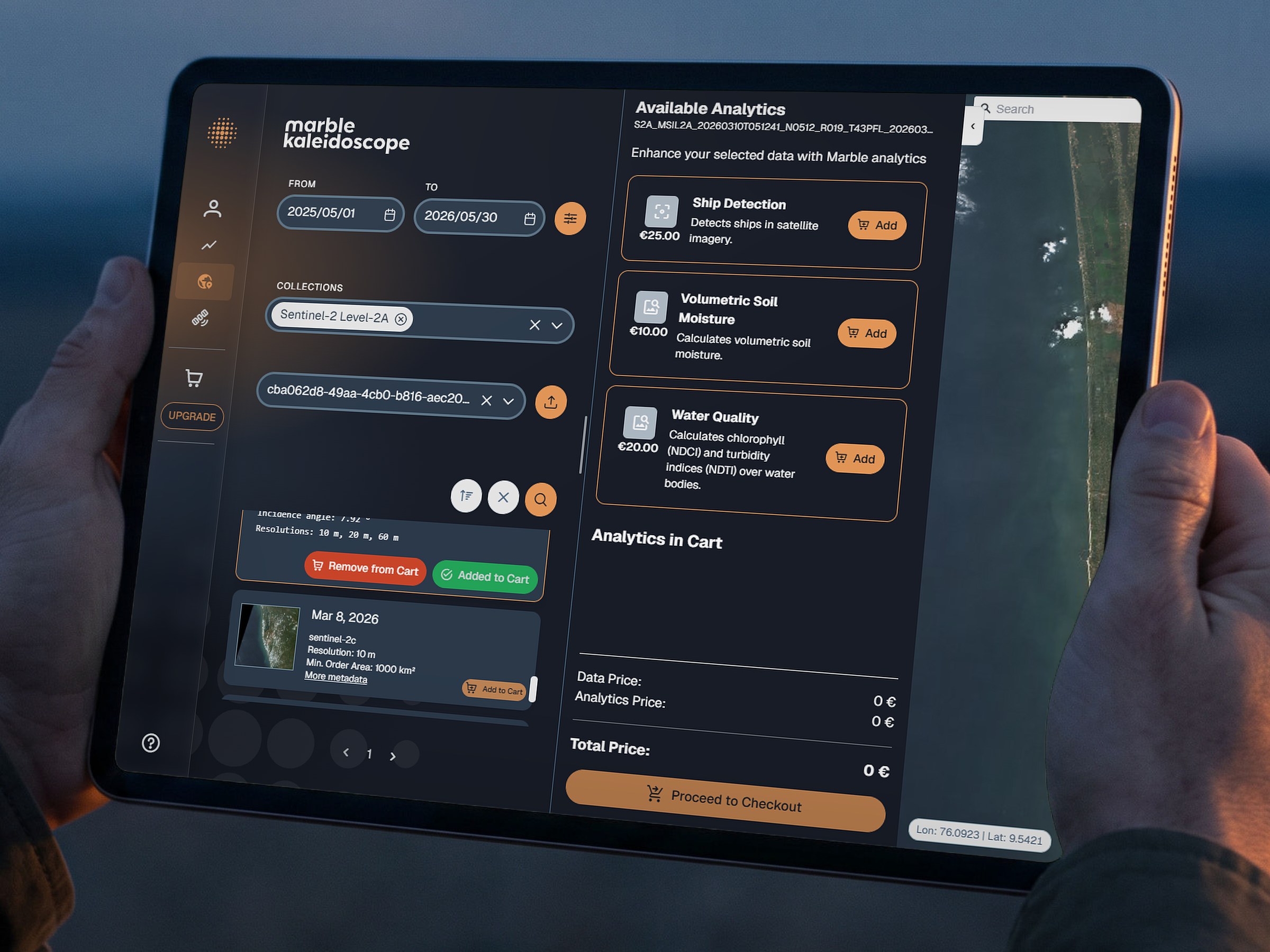
  1. Search the catalogue of archived multispectral imagery from Sentinel-2 by date range, collection and area of interest.

[ Interested in a demo? ]

Reach out to us directly.

Screenshot of Marble's geospatial data portal Kaleidoscope: a search panel with a date range, the Sentinel-2 Level-2A collection, an area of interest and Sentinel-2C results added to the cart; an analytics panel offering ship detection, volumetric soil moisture and water quality; a satellite map of a coastal lagoon with the search area marked in red and the map tools.
LON 76.0923 · LAT 9.5421 · SCALE 5 KMContains modified Copernicus Sentinel-2 data
Screenshot of Marble's geospatial data portal Kaleidoscope: a search panel with a date range, the Sentinel-2 Level-2A collection, an area of interest and Sentinel-2C results added to the cart; an analytics panel offering ship detection, volumetric soil moisture and water quality; a satellite map of a coastal lagoon with the search area marked in red and the map tools.
LON 76.0923 · LAT 9.5421 · SCALE 5 KMContains modified Copernicus Sentinel-2 data

[ 3.0 ]

DATA

An open archive today. Marble’s own data from launch.

Kaleidoscope gives access to public data as well as Marble’s future data and analytics, in the browser or through the API.

  • Public source (e.g. Sentinel-2)

    Status: In the catalogue

    Archived multispectral imagery from the Copernicus Sentinel-2 mission, searchable as Level-2A.

  • Marble analytics

    Status: In the portal

    Activity detection & monitoring, terrain & trafficability and maritime domain awareness, built on Earth Observation data.

  • Marble constellation

    Status: From launch

    Marble’s own very high-resolution multispectral imagery, VIS / NIR at 0.7 m and SWIR at 8 m, tasked through the portal. Marble Sat-1 is scheduled for launch in Q1 2027.

[ 3.1 ]

DELIVERY

Marble utilizes its in-house developed processing chain and partner ground station network to deliver constellation data to you as quickly and in the most secure way commercially possible.

  1. Marble constellationFrom Q1 2027
  2. Partner ground stationsDownlink
  3. In-house processingL0 → L2
  4. KaleidoscopeTask · purchaseanalyse
  5. YouBrowser or API

Being part of the Copernicus Contributing Missions program by the European Space Agency and European Commission, we comply with the highest standards when it comes to data delivery time, data quality and data security.

Technology

Portal prototype: the “Dragoscope” project with tenics, co-funded via LuRaFo by the State of Bremen and the European Union, managed by BAB.

[ 7.0 ]

CONTACT

Let’s build a future together.

Marble Imaging

European Earth intelligence, built in Bremen.

European Earth intelligence, built in Bremen.

CONTACT

Marble Imaging GmbH
Konsul-Smidt-Straße 8H
28217 Bremen, Germany

Funded and supported by
BREMEN 16:21:22 CET

53.0793° N 8.8017° E

53.0793° N 8.8017° E

© 2026 MARBLE IMAGING GMBH · AMTSGERICHT BREMEN HRB 41893 HB